
Imagine turning vast stretches of farmland into a digital canvas where every inch is mapped with precision. With satellite-based apps, this is not just a possibility; it’s a powerful tool you can harness to transform the way you manage your farm.
If you’ve ever felt overwhelmed by the sheer size of your fields or wished for a more efficient way to monitor crop health, you’re not alone. Many farmers, just like you, are discovering the incredible benefits of these cutting-edge technologies.
We’ll guide you through the simple steps to use satellite-based apps for farm mapping, so you can maximize yields, reduce costs, and make informed decisions with ease. Ready to revolutionize your farming experience? Let’s dive in and explore how these innovative tools can work for you.

Choosing The Right Satellite-based App
Satellite-based apps simplify farm mapping by offering precise field data. Farmers can monitor crops, plan efficiently, and boost productivity. With clear satellite images, decision-making becomes easier and more accurate.
Choosing the right satellite-based app for farm mapping can be a game changer in modern agriculture. With so many options available, how do you ensure you’re picking the perfect tool for your needs? It’s not just about tracking soil health or crop yield; it’s about finding a solution that fits seamlessly into your workflow and enhances productivity. As a farmer who once struggled with endless spreadsheets and manual mapping, I found that a good satellite app can truly transform how you manage your farm. But how do you choose the right one? ###Understand Your Farm’s Needs
Begin by assessing what your farm truly requires. Do you need detailed soil analysis or perhaps monitoring crop health? Identify the core issues you face daily. This will guide you in narrowing down your app choices. ###Research Available Features
Look into the features each app offers. Some apps provide real-time data and weather predictions, while others focus on historical data for analysis. Compare these features against your farm’s requirements. An app with advanced analytics might be beneficial if you’re looking to boost efficiency. ###User-friendly Interface
A complex app can slow you down. Opt for apps with intuitive design and easy navigation. You don’t want to spend hours trying to figure out how to use it. Remember, an app should simplify your life, not complicate it. ###Check Compatibility
Ensure the app is compatible with your devices. Whether you’re using a smartphone, tablet, or desktop, the app should work seamlessly across all. Compatibility ensures you can access farm data anytime, anywhere. ###Read User Reviews
Dive into user reviews and testimonials. They often provide insights that specifications can’t. Learn from others’ experiences. Their stories can reveal hidden advantages or drawbacks of an app. ###Evaluate Cost Vs. Benefits
While some apps might be pricey, they could offer substantial benefits that outweigh the cost. Consider if the investment will lead to better crop management or reduced labor costs. Sometimes spending a little more can save you a lot in the long run. ###Trial Periods And Demos
Look for apps offering trial periods or demos. This lets you test features without committing financially. Experiencing the app firsthand can be pivotal in making your decision. ###Customer Support
An app is only as good as its support team. Ensure there’s reliable customer service available. You want to know help is just a call away, especially during peak farming seasons. Choosing the right satellite-based app requires careful consideration and research. But once you find the perfect fit, the transformation in farm management is undeniable. What’s your farm’s biggest challenge, and how can a satellite app address it?
Setting Up Your Farm Map
Explore the potential of satellite-based apps for farm mapping. These tools provide detailed aerial images to assist farmers in planning and managing land more effectively. Enhance productivity by using precise data to identify field boundaries and optimize resource allocation.
Setting up your farm map using satellite-based apps can transform the way you manage your agricultural operations. These tools give you a bird’s-eye view of your land, allowing for smarter decisions and efficient resource allocation. Imagine being able to pinpoint exactly where to plant your crops or identify areas that need more attention. This digital approach to farm mapping is not only practical but also incredibly empowering.Choose The Right Satellite-based App
To begin, select an app that suits your farm’s needs. Consider factors like ease of use, the features offered, and the level of detail in the satellite imagery. Look for apps that provide real-time updates and have good customer support. If you’re unsure, check reviews from other farmers who have used the app successfully.Create A User Profile
Next, set up your user profile. This is where you input essential details about your farm. Include information like your farm’s location, size, and type of crops grown. A detailed profile ensures the app’s algorithms can tailor recommendations specifically for your farm. Think about how much more precise your operations could be with customized insights.Define Your Farm’s Boundaries
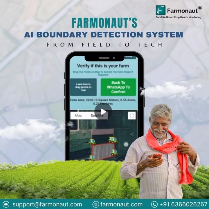
Accurately defining your farm’s boundaries is crucial. Use the app’s mapping tools to mark out your land. It’s like drawing a digital fence around your property. This step helps the app to focus on the right area when analyzing satellite data. Take your time; precise boundaries lead to better data analysis.Integrate Existing Data
Do you have existing data about your farm? Integrate it into the app. Whether it’s soil reports, previous crop yields, or pest control records, this information can enhance the app’s functionality. By combining satellite imagery with your data, you can gain deeper insights. It’s like having a personal assistant who already knows your farm’s history.Regularly Update Your Map
Keep your farm map updated. As seasons change or you implement new farming techniques, reflect these changes on the map. Regular updates ensure that the satellite app provides the most current data. How often do you check your farm’s progress? Make it a habit to review your map routinely.Analyze And Apply Insights
Finally, use the insights provided by the app. Look at the patterns and trends shown on your map. Are there areas with poor growth? Could certain sections benefit from more water or nutrients? These insights guide your decision-making process, helping you optimize your farm management strategies. Can you imagine the impact of making data-driven decisions on your farm’s productivity? Setting up your farm map with satellite-based apps is a game changer. It allows you to manage your farm with precision and foresight. Consider the possibilities and take the steps to map out your farm today. What new strategies could you implement with a clearer picture of your land?Leveraging Data For Farm Management
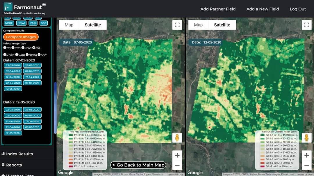
Leveraging data for farm management can transform agricultural practices. Satellite-based apps provide valuable insights for farmers. These insights help in making informed decisions. Farm mapping has become easier with this technology. It offers real-time data on soil conditions, crop health, and more. By using this information, farmers can optimize their resources effectively.
Understanding Soil Health
Satellite data helps assess soil conditions accurately. Farmers can identify nutrient deficiencies. They can also detect soil moisture levels. This information assists in planning irrigation schedules. It aids in applying fertilizers efficiently. Healthy soil leads to better crop yields.
Monitoring Crop Health
Satellite images provide detailed views of crops. Farmers can spot diseases early. They can also monitor pest infestations. This helps in taking timely action. Crop health monitoring ensures higher productivity. It reduces the risk of crop failure.
Efficient Resource Allocation
Farmers can allocate resources smartly using satellite data. They can plan the use of water, fertilizers, and pesticides. This reduces waste and saves money. Efficient resource allocation boosts farm profitability. It also promotes sustainable farming practices.
Weather Forecasting And Planning
Satellite-based apps offer accurate weather forecasts. Farmers can plan their activities accordingly. They can avoid losses due to unexpected weather changes. Timely weather information supports better decision-making. It ensures the safety of crops and livestock.
Tracking And Reporting
Satellite technology assists in tracking farm activities. Farmers can maintain records effortlessly. They can generate reports on crop performance. This helps in evaluating the success of farming strategies. Tracking and reporting enhance farm management efficiency.
Conclusion
Satellite-based apps simplify farm mapping. They offer precision and efficiency. Farmers can easily track crops and monitor soil health. This technology saves time and reduces manual errors. Adopting these apps enhances decision-making. It supports sustainable farming practices. Satellite data provides valuable insights for better yields.
It’s a practical tool for modern agriculture. Farmers can improve productivity and resource management. Embracing technology makes farming more effective. These apps are accessible and user-friendly. They fit well into everyday farming activities. A step towards smarter farming. Benefits are clear and significant.