Imagine having the power to see beneath the surface, predicting water flow, and making informed decisions to ensure clean and accessible water for everyone. That’s what Geographic Information Systems (GIS) can do for water resource management.
You might be wondering how GIS can revolutionize the way we manage one of our most precious resources. As you dive into this article, you’ll discover how GIS technology is transforming the landscape of water management by offering precise data analysis and visualization tools.
These tools empower you to tackle complex challenges, from flood prevention to sustainable water usage. Get ready to explore the fascinating role of GIS and see how it can be a game-changer in ensuring efficient and sustainable water resource management.
Gis Applications In Hydrology
GIS tools help manage water resources effectively. By mapping and analyzing water data, GIS aids hydrologists in understanding water patterns. This technology helps in flood prediction, water quality monitoring, and efficient resource allocation.
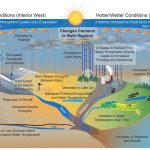
Geographic Information Systems (GIS) are revolutionizing how we manage and understand our water resources, especially in the field of hydrology. These powerful tools allow for the visualization, analysis, and interpretation of data to better understand water systems. By leveraging GIS, hydrologists can predict water flow, assess flood risks, and manage water resources more effectively.Gis In Rainfall And Runoff Analysis
GIS helps you analyze rainfall patterns and predict runoff. By mapping rainfall data, you can see how water moves across different terrains. This helps in understanding potential flood zones and planning effective drainage systems.Flood Risk Management
Using GIS, you can identify areas prone to flooding. The system allows you to visualize floodplain maps and simulate flood scenarios. This is crucial for developing strategies to minimize flood damage and protect communities.Water Quality Monitoring
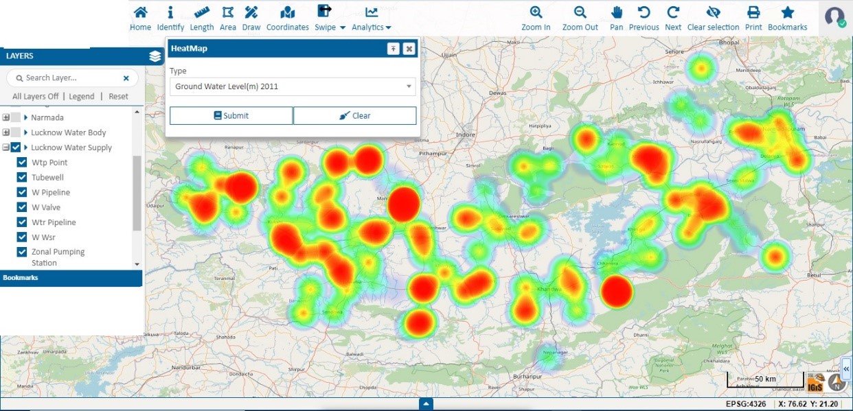
GIS is essential for tracking water quality over time. You can map pollution sources and monitor changes in water quality parameters. This helps in taking timely actions to prevent contamination and ensure safe water supplies.Groundwater Mapping
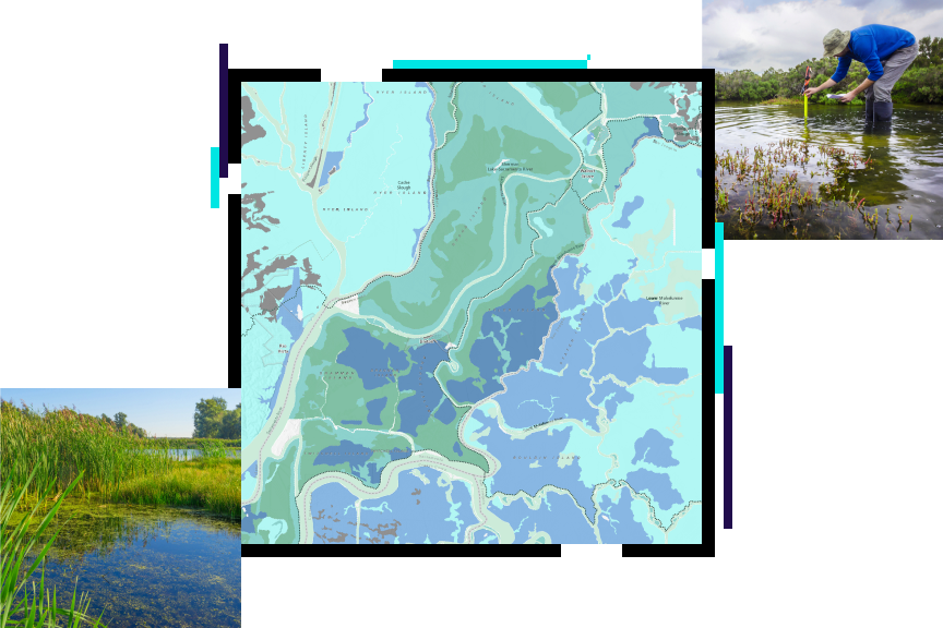
GIS allows for detailed mapping of groundwater resources. By analyzing data from various sources, you can identify aquifers and assess their recharge rates. This information is vital for sustainable groundwater management and preventing over-extraction.Watershed Management
With GIS, you can manage watersheds more effectively. The system helps in identifying land-use patterns and their impact on water resources. This insight is key to developing conservation strategies and maintaining ecological balance. Have you ever wondered how technology can make such a significant impact on natural resources management? GIS in hydrology not only answers this question but also opens up a world of possibilities for sustainable water management. By understanding and utilizing these applications, you can contribute to a more resilient and informed approach to managing our planet’s most vital resource—water.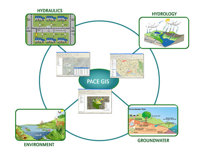
Data Integration And Analysis
Data integration and analysis with GIS are crucial in managing water resources. Combining data from various sources provides a clear picture. This helps in making informed decisions. GIS technology allows for better visualization and interpretation.
By integrating data, water managers can identify trends. They can address issues like water scarcity and pollution. This approach helps in sustainable management of water resources.
Data Collection And Integration
GIS collects data from multiple sources. These include satellite images, ground surveys, and sensors. All this information gets combined into a single platform. It creates a comprehensive view of water resources.
With GIS, data integration becomes seamless. Various datasets align to offer a clearer perspective. This helps in understanding the water cycle better.
Spatial Analysis And Modeling
GIS excels in spatial analysis. It helps in understanding the geographical aspects of water management. Spatial modeling predicts future water availability. It also identifies potential risks like floods or droughts.
This analysis aids in planning and management. It ensures that water resources are utilized efficiently.
Real-time Monitoring And Decision Making
GIS supports real-time data monitoring. This is crucial for immediate decision-making. It helps in tracking changes in water levels and quality. Real-time data allows quick responses to any threats.
Decision-makers rely on this information. They can implement strategies to manage water resources effectively.
Impact On Decision Making
Geographic Information Systems (GIS) transform decision making in water management. GIS tools help visualize, analyze, and interpret complex water data. These insights empower stakeholders to make informed choices. Understanding the impact of GIS on decision making can enhance water resource strategies.
Data Visualization And Interpretation
GIS offers dynamic maps for detailed water data visualization. Maps reveal patterns and trends easily. This aids in understanding water resources. Stakeholders interpret data without advanced technical skills.
Identifying Risks And Opportunities
GIS pinpoints potential risks in water systems. It highlights flood-prone areas and pollution sources. This information is crucial for proactive measures. Opportunities for sustainable practices are also identified.
Improving Resource Allocation
Accurate data guides efficient resource distribution. GIS helps allocate water efficiently. This ensures optimal use of water resources. Decision makers prioritize areas with the greatest need.
Enhancing Collaboration
GIS fosters teamwork among water management professionals. It provides a shared platform for data exchange. Professionals collaborate effectively to solve water issues. This leads to better decision making outcomes.
Supporting Policy Development
GIS data informs policy creation and adjustment. It offers evidence-based insights for policy makers. Policies evolve to address water challenges effectively. GIS ensures policies are relevant and impactful.
Future Trends In Gis Technology
The future of GIS technology in water resource management holds great promise. As technology evolves, GIS tools become more sophisticated and accessible. These tools help in better decision-making and efficient resource management. Let’s explore some exciting trends shaping the future of GIS technology.
Integration With Artificial Intelligence
Artificial Intelligence (AI) is transforming GIS capabilities. AI helps process vast amounts of spatial data quickly. This leads to more accurate predictions about water resource availability. AI-driven models can identify patterns in environmental changes. These insights are crucial for sustainable water management strategies.
Enhanced Data Collection With Drones
Drones are becoming vital in collecting real-time data for GIS. They provide aerial views of water bodies and landscapes. This data is essential for monitoring water levels and quality. Drones can access remote or hazardous areas with ease. Their use ensures continuous and comprehensive data collection.
Cloud-based Gis Solutions
Cloud technology makes GIS tools more accessible and collaborative. Users can share and analyze data in real-time from any location. This promotes teamwork and faster decision-making in water management. Cloud-based GIS also reduces the need for expensive hardware. It ensures that small organizations can leverage advanced GIS capabilities.
Real-time Data Analytics
Real-time analytics provide instant insights into water resource conditions. This helps in quick response to any changes or emergencies. Monitoring systems can alert authorities about potential issues. This proactive approach minimizes risks and ensures water supply safety.
User-friendly Gis Interfaces
User-friendly interfaces make GIS tools accessible to everyone. Simple dashboards and intuitive designs help non-experts use GIS effectively. This democratizes data and encourages wider participation in water resource management. Easy-to-use tools ensure more informed community involvement.

Conclusion
GIS tools greatly aid in managing water resources effectively. They provide clear insights and data visualization. This helps in understanding water distribution and usage patterns. Decision-making becomes easier with GIS technology. Communities can plan better for water conservation. Pollution tracking and prevention improve with GIS insights.
These tools are vital for sustainable resource management. GIS ensures informed choices for future generations. Protecting water resources becomes more efficient. It supports ecological balance and human needs. Embracing GIS leads to responsible water management. A brighter, water-secure future awaits.